Map Module
Содержание
Purpose
The module is designed to visually plan city deliveries and create rate zones on the map in the uniform zoning mode.
Orders on the map
You can monitor the number of forthcoming deliveries as well as known and undiscovered addresses by displaying shipments on the map.
On the Orders tab, highlight the orders and press SPACE or select the Go to Addresses context menu item. The Addresses tab displays the items you want to deliver or pick up. For convenience, the shipment list can be sorted.
To open orders on the map, on the Addresses tab, click on the button ![]() . To view a specific shipment, highlight it and select the Show on map context menu item.
. To view a specific shipment, highlight it and select the Show on map context menu item.
The «Map» window will open:

The top menu contains the following buttons:
![]() — all map overview;
— all map overview;
![]() — print visible area of the map;
— print visible area of the map;
![]() — display settings of the information on the map;
— display settings of the information on the map;
![]() — search by address or coordinates.
— search by address or coordinates.
In the panel on the left adjust the display of the courier list:
- select from the drop-down list the branch whose couriers you want to view;
- specify the managers whose couriers you want to display in the list;
- specify the scheduled delivery date for couriers. For the courier to be displayed in the list, the following conditions must be met:
- The courier's card shows the date of employment;
- The courier is set for free attendance or there is a schedule for the planning date. For more information see «Employee Schedules».
The window on the right shows a map with the addresses of the shipments marked by markers.
Undiscovered addresses
Addresses that could not be found on the map are displayed at the bottom of the window.
If address is not dispalyed on the map:
- double-click on the line of a missing address and in the shipment card to check the correctness of the spelling according to the rules for entering address information;
- select Search for an address on the map from the context menu of the list of addresses that were not found. If the address is found, drag the entry from the bottom of the window to the point found on the map;
- select Search for an address on the web from the context menu of the list of addresses that were not found. The default browser window opens with the address on the map. Copy the coordinates of the found address, paste them into the search bar at the top and click on the
 button. The map displays the found address as a green diamond. Drag the entry from the bottom of the window onto the point found on the map. The image of the diamond will disappear if you delete its latitude and longitude coordinates from the search line;
 - if you know the exact location of a missing address on the map, drag the address to the right place.
If the shipment marker is in the wrong place, uncheck the point using the context menu (the address will be moved to "not found"), and then drag it to the right place.
MeaSoft remembers all the addresses found and specified in manual mode, and then automatically replaces them when you work with the module again.
Settings
Settings are called up by clicking on the ![]() button. The settings window looks as follows:
button. The settings window looks as follows:

Map Settings
The tab is used to set the display of shipments on the map. You can select one of the options:
- Status colors — the shipment is marked depending on its status. You can change the default colors. To change the color, press the
 button to the right of the color, the window with the options will open. Select the desired one and press OK. This mode helps the logistician to see scheduled and unscheduled deliveries on couriers;
 - Courier colors — the shipment is displayed with the color of the marker assigned to the courier. There are 24 different colors for couriers. If all colors are already assigned, all subsequent couriers are assigned a white color. This mode helps you to see the delivery area on the map when the number of couriers is relatively small.
The tab is for adjusting the print contrast. A problem with map clarity can occur if the logistician is using a black and white printer.
To improve image quality, enter a print contrast enhancement factor.
Map printing options:
- print the map from the Map window. Click on the Print button at the top left;
- automated printing. Allows you to print the map along with the documents required when issuing the shipment. You can set up printingbefore or after the issuance of the certificate.
Существуют следующие варианты обозначения корреспонденции на печатной карте при выдаче:
- нумеруется корреспонденция. Внутри каждого квадрата находится порядковый номер корреспонденции из акта приема-передачи курьеру. Если получателю предназначены несколько отправлений, на карте в квадрате будут перечислены их порядковые номера из акта приема-передачи. Такой вид отображения удобен, когда курьеру нужно сообщить логисту о передаче корреспонденции получателю. Курьер сообщает номер корреспонденции, логист отмечает передачу в программе. Настройка переменной
- нумеруются адреса корреспонденции. Внутри каждого квадрата находится порядковый номер адреса. Если получателей несколько на один адрес, на вкладке Выдача в графе Номер в акте у нескольких корреспонденций будет один порядковый номер.Настройка переменной
Пример карты:

Hints
The tab is used to configure the hints that are displayed when you hover the cursor over the marker.
Hints are separately configurable to display the map in different modes:
- by the Addresses button - hints on the Addresses tab;
- by the Tracking button - prompts when viewing the courier's route in the tracking;
- by the Handover in Tracking button - prompts when viewing the issued shipment in the tracking.
Additional features
The system provides parameters that allow you to set the conditions of the marker display on the map. For example, you can mark pickups as large blue triangles, and evening deliveries as small yellow squares. For more information see «Programmer's Manual».
Note We strongly recommend that you do not change this setting without the help of a professional. You can contact us, the marker setup for support rates 2 and 3 will be free or inexpensive in other cases.
Scheduling types
- Courier scheduling using maps:
- manually
- using schemes
- by orders
- Scheduling by the list
- Routing:
Manual scheduling
Manual scheduling types:
- assign a courier to the marker. In the context menu of the shipment marker select Schedule. The order is scheduled for the employee selected in the list on the left. By default, it is the first courier in the list. To select a specific courier, in the context menu of the marker select Schedule for courier;
- moving markers. For example, a courier is scheduled for delivery and you want to add more shipments. Hold down CTRL and drag the free marker to the scheduled employee's marker. The result is that the two addresses are scheduled to be delivered by the same employee. If both markers already have scheduled couriers, moving one to the other will assign the shipment to the employee on whose marker it was dragged;
- area selection. Hold down the right mouse button and circle the area with the markers, then select Schedule for courier in the area's context menu. As a result, the dispatch of this area is scheduled for delivery to the specified employee.
Schematic scheduling
- Schemes
- Graphically highlighted contours of delivery areas saved on a map, possibly with couriers assigned to them.
Scheduling with schemes allows you to reduce manual work with the help of created delivery areas. Delivery districts can be resized or combined, depending on the weight, volume and number of shipments. For example, if you have a large amount of shipments, you can reduce the delivery area to divide the load between couriers.

Creating a scheme
- Select the orders, go to the Addresses tab and click on the
 button. The «Map» window will open.
 - Click Add.
- In the drop-down list, select the added scheme.
- Click on the
 button near the Add button and select Edit scheme.
 - From the context menu on the map, select Create outline. For more information see «Creating contours on the map».
- Use the right mouse button to position the points on the outline so that it forms a closed area. When the outline is ready, press ENTER. To merge adjacent outlines, select them while holding down CTRL and choose Merge outlines from the context menu.
- To assign a courier to an outline, select Set Courier from the context menu.
- Create as many outlines with assigned couriers as you need to work, and then click the Complete button.
- Click on the button near the Add button and select Schematic options. In the window that opens, specify the name of the scheme and select the branch to which the scheme will apply.
The context menu item Specify zone number is used in client automation that is not included in the standard delivery. Details
When creating outlines, do not allow voids and intersecting contours. If the delivery or pickup address falls in an empty space between contours, then in the semi-automated scheduling no courier will be assigned to the delivery. If the address falls on an intersection of contours, the courier will be selected randomly from those assigned to the intersecting areas.
To use the outlines of one scheme for another or to create a new one, use the Copy Scheme function in the drop-down menu next to the Add button.
Scheduling
To start scheduling, in the "Map" window select the created scheme from the drop-down list and click on the button Schedule all. Shipments will be distributed among the working couriers, and a report will be generated in a separate window when the operation is completed. You can use ways of manual scheduling.
You can schedule one courier for several areas. To do this, select the districts by holding down CTRL and select a courier from the context menu.
Note: The temporary area drawn on the scheme has a higher priority. Temporary outlines can be used to assign another employee when one courier is scheduled for a large number of shipments that they will not be physically able to deliver.
You can create separate schemes for different cases of delivery areas: the amount of shipments, weekdays or weekends, holidays, etc.
Deleting a scheme
In the "Map" window select a scheme from the drop-down list, click on the button ![]() near the Add button and select Delete scheme.
near the Add button and select Delete scheme.
Manual routing
You can plan the courier route and generate trip sheets with a specified sequence of points.
- In the "Map" window, click the Delivery button. If there are shipments scheduled for courier on the specified date, the routes are automatically generated and displayed on the map. The points in the routes are arranged in random order.
- Correct routes if needed and click on the Accept all routes button. Point numbers in the route are recorded in the trip sheets.

The information in the Delivery panel is grouped by tabs:
- Scheduled - general information about the formed routes. Fields "Departure", "Arrival", "km" are not filled;
- Not Scheduled - a list of shipments that are not scheduled for a courier or date or not found on the map.
You can use ways to create routes manually on the map to indicate the courier.
Запланировано
В таблице «Маршруты» содержится общая информация о сформированных маршрутах.
Возможные действия:
- добавить новый маршрут для курьера, еще не указанного в списке — в контекстном меню выберите Создать новый маршрут и укажите сотрудника;
- запланировать сформированный маршрут для выбранного курьера — в контекстном меню выберите Запланировать;
- назначить другого курьера для сформированного маршрута — в контекстном меню выберите Запланировать для курьера.
В таблице «Адреса» перечислены точки, входящие в маршрут курьера, выделенного в таблице «Маршруты» выше. Точки в маршрутах располагаются в случайном порядке. Вы можете перемещать точки:
- внутри маршрута — комбинацией клавиш ВВЕРХ + CTRL и ВНИЗ + CTRL или с помощью пунктов контекстного меню Передвинуть выше и Передвинуть ниже;
- между маршрутами — используйте пункт контекстного меню Переместить в маршрут. Точка добавляется в конец списка адресов.
Выделенная в списке точка подсвечивается в маршруте на карте.
Отправления, не подходящие для доставки в указанную дату, выделяются розовым цветом. При наведении на такие строки курсора мыши отображается подсказка с причиной ошибки. Вы можете открыть соответствующую корреспонденцию двойным щелчком по строке и исправить данные.
Чтобы подтвердить сформированные маршруты, нажмите на кнопку Подтвердить все маршруты. Номера точек в маршруте заносятся в путевые листы.
Не запланировано
Вкладка содержит список отправлений с ошибками планирования. Строки выделены розовым цветом, при наведении курсора мыши на строку или в столбце «Примечание» отображается подсказка с причиной ошибки:
- не запланирован на курьера — используйте пункт контекстного меню Переместить в маршрут. Точка добавляется в конец списка адресов маршрута;
- не подходит план. дата доставки — откройте корреспонденцию щелчком по строке и исправьте дату доставки;
- местоположение не подтверждено — выполните действия, описанные в разделе «Ненайденные адреса»;
- курьер не доступен по графику — убедитесь, что в карточке курьера есть график на дату планирования.
Картографическая система
Программа MeaSoft работает с картографической системой OpenStreetMap.
Проект создан сообществом картографов, которые добавляют и поддерживают данные о дорогах, тропах, кафе, вокзалах и многих других объектах по всему миру.
Карты OpenStreetMap позволяют создавать области и тарифицировать зоны, назначать курьеров в окне Карта, планировать курьеров на доставку.
OpenStreetMap не умеет строить маршруты курьеров, для работы с новыми областями необходимо постоянное подключение к интернету. Просмотренные области карты кешируются и в дальнейшем доступны для работы даже без интернета.
Система OpenstreetMap в программе MeaSoft не требует никакой региональной настройки и сразу готова к работе.
Геокодирование
Для отображения любой информации на карте используется геокодирование.
Если в офисном приложении координаты адреса неизвестны, оно отправляет запрос в геокодер MeaSoft: передает город и адрес, в ответ получает координаты, которые сохраняются в кеш программы. Поэтому, прежде чем отправить запрос в геокодер, сначала проверяется, нет ли данных для этого адреса в кеше. Если есть, запрос к геокодеру не нужен.
При записи и чтении из кэша срабатывает упрощение адреса: до первой запятой — считается улицей, 5 символов после — номер дома. Использование упрощения адресов определяется переменной Справочники > Переменные > Подключения > Карты > Геокодирование > Отключить упрощение адреса при геокодировании:
- если упрощение включено, в кеш записывается не весь найденный адрес, а только часть. Перед поиском адрес также сначала упрощается. Например, адрес вида «Солнечногорск, улица Островского, 1» и «Солнечногорск, улица Гоголя, 1» упрощается до «Солнечногорск, улица». И программа оба адреса сведет к одной точке. При включении упрощения точность до дома не гарантируется;
- если упрощение адреса выключено, поиск и запись адреса в кеш ведется в том виде, в каком он указан, и время определения координат может увеличиться. При разнице хотя бы в один символ нужен повторный запрос к геокодеру. Например, эти адреса будут разными: «Солнечногорск, улица Островского, 1» и «Солнечногорск, улица Островского, д1».
Для улучшения результатов геокодирования при включенном упрощении указывайте адрес по стандарту MeaSoft. Например, в поле Адрес нужно указать «улица Островского, 1», а в поле Город указать «Солнечногорск». Тогда точность будет высокой при хорошей скорости геокодирования.
Если геокодер MeaSoft не нашел адрес, он может сделать запрос к платному геокодеру: Ахантер и к Яндекс. Картам. Сервер геокодирования Яндекс. Карт, получая запрос, преобразует адреса в координаты и ищет соответствия по своей базе данных, затем возвращает адреса в программу. В окне «Карта» отображаются маркеры адресов, которым сервер Яндекс. Карт смог найти соответствия.
Данные сервера геокодирования Яндекс. Карт находятся в Справочники > Переменные > Подключения > Карты > Яндекс > Сервер геокодирования Яндекс.
Чтобы адреса корректно определялись на карте, перейдите по ссылке и получите ключ «JavaScript API и HTTP Геокодер», затем укажите его в Справочники > Переменные > Подключения > Карты > Геокодирование > API-Ключ.
Единое районирование
- Единое районирование
- Cистема планирования работы курьеров, при которой заказы распределяются по районам, нарисованным на карте. Этот метод пришел на смену планированию по станциям метро. Единое районирование работает для всех филиалов компании.
Чтобы включить единое районирование:
- Выберите Справочники > Переменные > Финансы > Расчет района по адресу, установите значение переменной 1 и нажмите Сохранить. При этом автоматически включатся связанные переменные Расчет стоимости по адресу и Расчет зоны курьера по адресу.
- Можно включить единое районирование для отдельных пользователей. Для этого после 0 укажите через запятую именаконкретных пользователей и нажмите Сохранить:
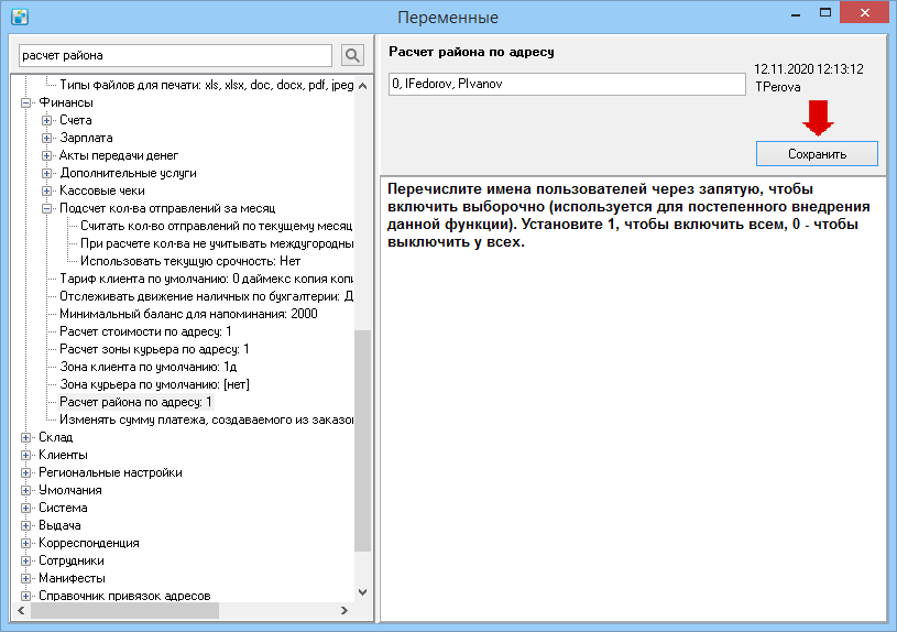
- Можно включить единое районирование для отдельных пользователей. Для этого после 0 укажите через запятую имена
- Выберите Справочники > Переменные > Корреспонденция > Планировать по курьерам в режиме многофилиальности. Возможные значения переменной:
- 0 — адреса на карте планируются по районам, в окне слева будет отображаться список районов;
- 1 — адреса на карте планируются по курьерам, в окне слева будет отображаться список курьеров.
- Чтобы внедрять функциональность в работу постепенно, в переменных можно указать отдельных пользователей аналогично действиям в пункте 1.
- Установите значение переменной и нажмите Сохранить.
- Выберите Справочники > Переменные > Умолчания > Псевдоним метро и введите название, которое заменит слово «метро» в интерфейсе программы. Например, «районы».
- После изменения значения переменных перезагрузите программу MeaSoft.

После включения единого районирования станут недоступны справочники Метро, Улицы, планирование по станциям метро. Чтобы установить тарифные зоны:
- Выберите Справочники > Районы, нарисуйте районы доставки на карте и закрепите за ними курьеров для автоматического планирования.
- Выберите Справочники > Зоны на карте и нарисуйте зоны курьеров и/или клиентов. Подробнее см. раздел «Зоны на карте».
По завершении всех настроек на вкладке Адреса выделите несколько адресов и нажмите на кнопку ![]() . В зависимости от значения переменной Планировать по курьерам в режиме многофилиальности на карте в окне слева отобразится список курьеров или районов доставки. Если отображается неполный список курьеров, перейдите в карточку отсутствующего в списке сотрудника и проверьте, указаны ли у него дата приема на работу и график работы.
. В зависимости от значения переменной Планировать по курьерам в режиме многофилиальности на карте в окне слева отобразится список курьеров или районов доставки. Если отображается неполный список курьеров, перейдите в карточку отсутствующего в списке сотрудника и проверьте, указаны ли у него дата приема на работу и график работы.